Projects
Data
Field campaigns provide data in hot spots of aerosol pollution in Africa, South and East Asia, Europe and South America. We use these data in order to test the quality of our data analysis methods and to carry out research work. For this purpose we established a global network of cooperation partners in internationally highly recognized research institutes in Europe, Asia, and North America. Most important partner institutes are the Leibniz Institute for Tropospheric Research (TROPOS) in Germany, NASA Langley Research Center (LaRC) in the USA and our partner laboratory at GIST in South Korea.
 Current projects
- Characterization of Asian mineral dust with multiwavelength Raman lidar in South Korea
- Lidar observations of East Asian aerosol pollution under daylight conditions
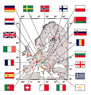
- European Aerosol Research Lidar Network (EARLINET): Long-term monitoring of aerosol pollution over Europe
The map shows member stations of EARLINET. Red dots show active Raman lidar stations. Yellow circles indicate high-performance stations; for explanation see description on multiwavelength Raman lidar. Green dots show EARLINET members that do not provide lidar data but are active in algorithm development. Blue dots indicate member stations that are no longer active. Malta (green dot with blue circle) is no longer active.
- Neural networks: applications to aerosol characterization with remote sensing technologies
- Development of novel regularization methods to be used in data inversion algorithms
- Development of synergistic algorithms for combined analysis of lidar/sunphotometer/starphotometer/DOAS instruments within ACTRIS
 ITaRS: Initial Training for atmospheric Remote Sensing. Our laboratory is involved in training of PhD students and early career scientists in the field of remote sensing with lidar.
- SALTRACE (Barbados, Caribbean Sea): investigations of aged mineral dust transported from North Africa to America, and the impact of dust on cloud properties
- GALION (GAW Aerosol Lidar Observational Network) : establishment of a network of high-performance aerosol lidars in pollution hot spots. (View the WMO report)
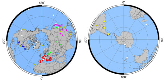
Map of North and South Hemisphere with lidar stations participating in GALION. The meaning of the dots is as follows:
- Red: European Aerosol Research Lidar Network - EARLINET
- Green: CIS-LiNet
- Pink: AD-Net - Asian dust and aerosol lidar observation network
- White: MPLNet - Micropulse Lidar Network
- Yellow: Latin American Lidar Network – LALINET
Details are given in the WMO report on GALION.
Some important past projects
- Development of a Raman lidar system for investigations of the mixing state of Asian dust, anthropogenic pollution, and clouds in South Korea
- Saharan Mineral Dust Experiment (SAMUM) in Morocco and the Republic of the Cape Verdes: characterization of optical, microphysical, and radiative properties of Sahara mineral dust (in cooperation with IfT) and research institutes and universities in Germany
- ICAROHS: Feasibility study to explore the potential of space-borne multiwavelength high-spectral-resolution lidar for aerosol characterization (in cooperation with IfT and the German Aerospace Center)
- European Integrated project on Aerosol Cloud Climate and Air Quality Interactions (EUCAARI): multiwavelength Raman lidar observations near Manaus (Amazon region, South America), New Delhi (India), and China and South Africa (in cooperation with IfT and the Finnish Meteorological Institute)
- Convective and Orographically-induced Precipitation Study (COPS): investigations of aerosol pollution on cloud properties (in cooperation with IfT)